Sunday, September 28, 2008

Skagway

OK, this seems like it was years ago, but I’ll try to give you my impressions of Skagway. I suppose we started our side trip down to Skagway with very high expectations, as everyone had great things to say about it. As mentioned earlier, we only had limited views of White Summit and the gorge as we descended to the town, and once we made it down, it was gray and very windy.

There’s a sense of two towns as you drive through, with the Skagway that people actually live in, and the Skagway that people get off of large boats to see. In season, Skagway is very much driven by the cruise ship industry, and there was at least one boat in each day that we were there. While the ships are there, the “touristy” shops are all open plying their wares (which are exactly the same as was available, or will be available, at all the other ports of call in the inside passage with the exception of “Skagway” being printed on all the shirts). Somewhere, there is a clothing producer with a bunch of stock t-shirt and jacket designs with an “insert town name here” computer program. As soon as the last ship leaves for the day there is this collective sigh of relief from the town, and the tourist drags suddenly become a veritable ghost town. You can walk down the center of the street with no fear of being hit by any tour buses, and see only the occasional seasonal employee scurrying into the only businesses remaining open (the bars, of course). You can even hear the hanging signs creaking in the wind. The only thing missing are the tumbleweeds blowing though.

One of the reasons I was excited to visit Skagway was the history of the town as it relates to the Klondike Gold Rush of 1898, and while some of this historical perspective was a bit kitschy, with the tour guides dressed in their period costumes dramatizing the life and death of Soapy Smith, there was still enough for those seeking greater historical depth. There is a small, but legitimate museum in the McCabe building, which was built of granite in 1899, and has served as everything from a school and college, to a court house, jail and marshal’s office over the years. Now it houses the museum and otherwise serves as city hall.


This is the hall of the Arctic Brotherhood, which is decorated with the ever popular driftwood siding.


This is the main drag of Skagway just one half hour after the last ship of the day left. This is about 5 PM, and the rush hour pretty much consisted of a guy riding by on his bike with not one, but two dogs jogging alongside. Clearly, just short of gridlock... (Laura makes a cameo at the street corner in the yellow jacket). On the kitschy side, Laura was determined to have a beer in the local brothel, The Red Onion, which offers tours of the “facility” at the rate of “$5 for 15 minutes, the same as in 1899,” in addition to the bar and souvenir shop on the first floor. I went along, but only because she made me.


The other historical highlight in town is the White Pass and Yukon Route small gauge railroad, which was built to transport gold miners that didn’t feel like carrying their literal ton of gear up Chilkoot Trail and Pass. Unfortunately, by the time the railroad was ready to go, most of the Rush had passed, but it served the US Military well transporting men and equipment to the construction of the Alaska Highway during WWII.

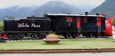

This is the White Pass & Yukon Route "Snow Plow No. 1," which was built in 1899 by the Cooke Locomotive and Machinery Company of Patterson, NJ, and was in service until 1964. During that time, it made 2580 trips and logged 181,000 miles, clearing the tracks of snow via it's huge bladed snow thrower.


My personal highlight was our trip out to the start of the aforementioned Chilkoot Trail, which started at the town of Dyea. Before the Klondike Stampede, it was a tiny native village and trading post, but during the Rush, it boomed to 8000 people in a muddy shanty town, built to exploit the miners as they began their quest for riches. However, with the completion of the railroad, the steady supply of stampeders dried up, and by 1903, the population was a massive 3 people. For the most part, the town was disassembled and the materials were packed off, leaving very little signs that the town ever existed. The town site is now trees and meadow, and it is amazing to try to picture a bustling town existed there just over a century ago. It’s now a national historical park run by the park service, and you can walk through the woods trying to imagine the street grid as shown in the walking tour handout. All that’s left are a few ruins of a rowboat, a warehouse, and the false front of a business in the town (these fronts were used to make a more impressive first impression to prospective customers, as opposed to the flap of a tent.


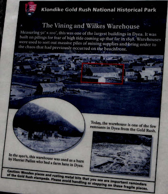
This is the remains of the Vining and Wilkes Warehouse, which is described by the sign below. Note all the buildings around it in the sign, as compared to the literal forest surrounding the lonely remains above.


There is also a stampeder’s cemetery for those killed in an April 3, 1898 avalanche, which includes at least one from what we think was Punxsutawney PA, spelling issues aside. It was a pretty surreal experience to imagine what it would have been like to be one of those miners arriving in Dyea a century ago, just starting out on their Alaska and Yukon adventure.


Oh, yeah, Skagway has a pretty good micro-brewery too, and they also have a good Spruce-Tip Ale. They were closed when we first got to town for their end of season employee party (much to the consternation of some of the cruise ship tourists who were only in town for the day), but a few bleary-eyed, hung-over, junior employees had the honor of dragging themselves in the next day for our benefit.

The Alaska Highway:

OK, getting back on the road, I have just one more thing to say about the Alaska Highway, as I think I’ve already beaten that horse pretty well. While some stretches were monotonous and boring, and others were stressful due to the road conditions and our seemly daily required allotment of fog, I have to be fair. We were fortunate to be on the highway during the height of the fall colors for most of the highway, and there were stretches that were just incredible. The area surrounding Muncho Lake is flat beautiful, and I found myself gawking at the northern portion of the Canadian Rockies (it was fortunate that traffic is light at this time of year, because we were able to rubberneck and really take in the scenery as we drove). Those of you that know me know I’m not prone to hyperbole, but expressions such as “child-like wonder” and “dumbstruck and speechless” came to mind during those stretches (yeah, I can hear the wise-ass remarks regarding me and ‘speechless’ already).

The big draw at Watson Lake is the sign forest, shown below, which now has well over 100,000 signs. Seems a homesick GI assigned to the construction of the highway during WWII put up a sign indicating the distance to his hometown, and since then the idea has taken root (sorry for the pun, but they're necessary once in a while). Now, many people traveling the highway actually have signs made ahead of time for the express purpose of leaving them behind. There are also quite a few travelers who evidently decided that their license plates were extraneous and left them behind as signs.


Getting to Dawson Creek, the start of the Alaska Highway, turned out to be pleasant weather-wise, but somewhat anti-climactic. I kinda thought there'd be more from a historical standpoint than the little visitor's centers/gift shops that were near mile zero and mile one. So much so, that I never even bothered getting out the camera to take a picture of the zero milepost. In any event, we took a day to refresh ourselves and clean out the RV a bit before heading south.

For my next edition, I’ll wrap up Canada with our visits to the Jasper/Banff area and Calgary.

Friday, September 19, 2008

more random thoughts


I haven't had a chance to download my pictures from Skagway yet, so I'll have to treat you to some more wanderings of an addled mind...

~I found it interesting to look at the various burns as we continued on east and south on the highway. By "burns" I mean the aftermath of all the wildfires which have occurred on the surrounding lands. It became a bit of a game to try to guess how long ago the fire occurred based upon the regrown vegetation. The most recent burn was only 2 years ago, and you could just start to see some of the sapling quaking aspen peek over the regrown grass and weeds (such as fireweed, so named because it is one of the first things to grow in soil after a wildfire). Then there are the 5-10 year old burns where the aspens have just started to look like real trees, popping up around the standing skeletons of the burned trees which have not yet completely given up the ghost. After that, pretty much all the standing dead wood has fallen to decompose and fertilize the soil, and the aspens have really come in thick, but with the beginnings of competition from the conifers (mostly white and black spruce in the areas of the Alaska Highway). Finally, where some of the old burns from the mid-1900's occurred, you now see the beginnings of mature forest, in which the conifers again reign supreme.

OK, on that note... time for a somewhat obscure music trivia question: Name the rock group who sung of "trouble in the forest," concerning competing species of trees. Extra credit if you can name the album (do they still call them that?), and a gold star if you can name the warring species. I'll figure out some kind of a prize for the first correct answer.

~Once you get past Fort Nelson headed east on the highway, you get into some serious straightaways. The longest I kept track of was 7.5 miles. As long as you're vehicle is properly aligned and you have cruise control, the driver becomes essentially superfluous. As I was sitting there bored, I couldn't help but think of the ESPN commercial where Boston Celtics players were watching the end of the movie Hoosiers as they were road tripping in an RV, only to find that the driver, Coach Jeff Van Gundy, was standing there watching with them. The commercial ends with a view of the RV veering onto the shoulder. I'm pretty sure that on some of those straightaways I could have watched the entire ending of Hoosiers from the time they step out onto the championship court in the huge field house and Gene Hackman's character has his team measure the court to show them that it's the same size as their own small hometown gym's.

~Oh yeah, one more comment about the road signs- Is it really necessary to post a horse crossing sign 100 yards (oops, meters) after a moose crossing sign? Are Canadian drivers so focused in their vigilance regarding moose in the roadway that they would miss a 1000 pound horse blocking their lane? Or did they just not want the horses to feel left out... I think they just need a sign stating "HUGE ANIMALS IN YOUR WAY- LOOK OUT" Well, that and the occasional randomly placed "CAUTION" sign to keep you on your toes...

~We saw a big gaggle of geese flying south as we were entering Fort Nelson. I'd say they were flying in a "V" formation but these guys must have been taking Chinese because they kept forming what appeared to be the characters of the entire Chinese alphabet. I still knew they were Canada Geese, though, because I kept hearing "Honk, eh?" (What, this far into Canada for my first "eh", joke? -quit complaining). By the way, the "ehs" are driving Laura nuts, so please throw a few into any correspondence you may have with her.

~Our dogs are still doing well and are becoming seasoned travelers, though Eugene has to sit up front with us and pant the entire time we're moving. I'm trying to come up with a new rating system for how bumpy the roads are based upon the radius of drool spatter around his position. It's OK to laugh though, since he sits closer to Laura than me when I'm driving. :) She actually has to sit there with a towel on her lap in order to stay dry.

I'll leave you with that for now, with the as yet unfulfilled promise of more meaningful posts to come...

Thursday, September 18, 2008

Random Thoughts from the Alaska Highway

Since we’ve now reached the end, or more accurately, the start of the Alaska Highway, I thought I would offer a few random thoughts about the road and those that maintain and live along it before I fill you in on our travels to date…

We were almost able to complete our “Alaska Highway Collection” of roadside wildlife: We’ve seen the standard issue moose, coyote, caribou, elk, whitetail deer, the squirrel trio (red, grey, and artic ground), bison (wild and domestic), and if you count the browns in Haines, bear as well. Unfortunately, we did miss out on the stone sheep in the Yukon, which are similar to big horns, though somewhat smaller and gray in color. At one point, a mother lynx was ushering her four kittens across the highway, though by the time I was able to stop, this was the only view I was able to capture…


We even saw a Yukon cousin of Punxsutawney Phil, (for those of you not familiar with the lore of the prognosticating Pennsylvanian of Punxsutawney, I refer you to the Bill Murray movie “Groundhog Day.” Phil was the feisty fellow who Murray’s character had to remind “Don’t drive angry,” just before they made their suicide compact and drove into the ravine. I really liked Laura’s comparison of the herd of a hundred or so Bison who were lounging along the roadside to the scene of so many beached walrus. Henceforth, I will refer to all bison as ‘land-walrus,’ (unrelated to the ‘land-shark’ of classic Saturday Night Live fame). For a photo of the land-walrus, you'll have to check out Laura's blog- I was busy driving through the herd.

This brings me to my next random thought- the road signs relating to the crossing of the aforementioned wildlife. As we progressed, several of the signs seemed to indicate regional disparities among species. For most of the Highway, the moose crossing signs were similar to the ones I’m familiar with in Alaska, but as we drove deeper into British Columbia, the signs depicted these bull moose in a manner which I can only describe as bulked up super moose on steroids. If the signs are accurate, these Mark Maguire Moose must wreck havoc on even the largest trucks in the event of a roadkill. At one point, near Muncho Lake, the whitetail crossing signs changed from the typical parallel leaping deer (think John Deere) to one version which seems to depict the deer in the area as if in a suicidal charge straight at your front end. Finally, there are the sheep crossing signs (oddly, also in the Muncho Lake region-must be something in the water) which are two-parters, with the left portion of the sign showing a car approaching a ram, and the right side cruelly showing a smashed up car driving over the hapless ram. Evidently, the road maintenance people are very politically correct, and wish to cater to those who may be causality-impaired.

More on road signs:

There are several sections of the road which have been resurfaced via the tar-and-chip method, and which had not had lines painted on them yet. On one particular section, we had been traveling for several miles when we came upon a sign which advised belatedly of “No Lane Markings.” For those of you travelers who had not yet noticed this subtle change, in the words of Bill Engvall, “Here’s your sign.”

For the most part, Canadians seem to be pretty good at warning you of impending roadside doom, but at one point, after several miles of nothing unusual, we came upon an orange warning sign stating simply “Caution.” There was no other elaboration, no other signs, and nothing else of note for several more miles, ah, kilometers. Apparently this sign is for those travelers lulled into complacency by those endless miles.

Near one roadside lodge, the residents are concerned enough for highway safety as to have erected signs warning of “Sasquatch crossing,” though these particular big foots (big feet?) seem to have a taste for Canadian beer, as they are depicted as having just purchased a case of Kokanee.

Finally, on the dirt the highway deposits on vehicles: There was a work truck stopped at a roadside pullout with quite a thick layer of dirt on it. Written in the dirt was the following: “I wish my woman was this dirty.”

On that note, I’ll call it a post, with the promise of writing something more meaningful soon…

Wednesday, September 17, 2008

Catching up...

In the next couple installments, I’ll try to catch you up on our travels since leaving Haines. So, for those of you planning on soldiering through the whole thing, no need for ambien tonight!

When we headed back up towards Haines Junction, the weather had indeed improved from our trip down, though we still had some fog to contend with. All things considered, if you’re planning a trip down the highway and have the time, this isn’t a bad side trip to take (albeit a 300 mile, round trip jaunt). The roads are in excellent condition, and Haines is an interesting, if small town. As far as Southeast towns go, this one doesn’t seem to have been as significantly affected by the cruise ships it does get (although they only get a fraction of the ships compared to some of the Inside Passage towns). The same cannot be said for Skagway, but more on that later.

Whitehorse, Yukon Territory, was our next stop. This is the seat of government for the territory, and as such accounts for more than half of the entire region’s population with a whole 24,000 people. Like Anchorage, because it is the economic and resource center for it’s region, it has perhaps more infrastructure than would be the case in a lower-48 city/town of similar size. There are a couple of cross streets which seem to cater to the tourists, but there is a very nice riverside park area with bike paths, a kid’s water fountain for the hot weather, and the occasional beached stern-wheeler from the riverboat days (OK, only one, but it’s not everyday you turn the corner in the bike path and are faced with a 210 foot long steamboat sitting high and dry). The Klondike II (the first one was destroyed when it ran into a sandbar) was capable of moving 300 tons with a draft of only 4’. Unfortunately, I didn’t have my camera with me on our walk, so I can’t give you a sense of it’s size, but it’s flat amazing that such a large vessel would have only a one foot draft when empty. It’s pretty interesting to look out over the Yukon River and picture all the commerce and river traffic during the steamboat and gold prospecting heydays.

The northern terminus White Pass and Yukon Route small gauge railroad used to be here, but the train now only functions as a tourist ride to the summit out of Skagway, though they do combo tours where bus service will get you the rest of the way. These days, Whitehorse has a reasonable shopping area if you need to restock on supplies, and even has an RV-friendly Walmart. Of course, Whitehorse has those critical establishments such as McDonald’s, KFC, and a Boston Pizza (apparently, removing the “‘s” takes an American establishment and renders it Canadian…). However, that most critical of businesses, the microbrewery, is well served by the Yukon Brewing Company. I have to say that all this remoteness allows these guys to spend a lot of time perfecting their recipes, and the local population doesn’t seem to take it for granted. While we were there, there was a steady stream of locals filling their growlers for the weekend, and apparently, for the Friday afternoon at work, based upon some of the conversations (clearly, the Canadians subscribe more to the European mentality when it comes to alcohol). In any event, if your driving through and have ANY proclivity towards a good brew, it’s a must stop.

Our next side trip was down to Skagway, which everyone told us was a very picturesque drive, and a “can’t miss.” Well I’m sure it is, but the drive down from White Summit was just that- white. We were enshrouded in fog with less than 50 yards visibility most of the way down, so we had no real sense of the hundred plus foot drop-off on the other side of the guardrails, which I suspect, Laura didn’t mind at all. Just prior to the 10.5 mile steep downhill from the summit (Which the Whale handled surprisingly well) is the summit area surrounding Fraser. With it’s mountain tarns, stunted black spruce and it’s lichen covered rock and boulder strewn “moonscape,” this area was downright spooky in the fog.

Laura’s starting to give me dirty looks, as we need to hit the road, so I guess we’ll leave this as “to be continued…”

Monday, September 15, 2008

Bears, bears, bears

OK, so I've promised you all some more bear photos, but I'm amazed at how busy I am now that I'm "retired." It's hard to sit down in front of a computer when there are other, more interesting things to do. Well, here's a few of them until I feel sufficiently motivated to catch you up on where we're at and what we've been up to.


Now, as I post this next one, I can imagine the collective whispers to the bus driver from all the Alaskans out there who find our tourists oh so endearing each year.
"Let them out...let them out..."
Of course, the bear may be whispering the same thing...


This next picture is of the rare English Pointer Brown Bear. You can't see it, but his tail is straight out as well. This rare bear will stay on point on the fish until it's owner/handler releases him.
OK, maybe not, but this photo reminded me of my brother-in-law Mark's bird dogs, and I couldn't resist...


The next photo answers one of those eternal philosophical queries...


Yes, indeed... a bear does SIT in the woods. Oh and as you can tell, they obviously also stand in the woods. This one is, of course a male caught unawares...


The photo above provides the real explanation as to why most bear maulings occur when a bear is surprised. You see, they don't want you running off and telling everyone how STUPID they look when they're surprised...
(And no, I didn't doctor that photo.)


Finally, if you're not "dazed and confused" at this point, he sure is...

Thursday, September 11, 2008

Haines


OK, so for some reason I thought that the roads were going to get better once we got into Canada. Not so much. The first section after entering the Yukon was worse than any in Alaska, with even more “diver-down” flags. However, I have yet to figure out exactly what criteria is used to determine the placement of those flags. I think they just load them up in a pick-up bed and then drive the road at 55 MPH, excuse me, at 90 KPH, and where they bounce out as the truck goes airborne, they come back and put them up. Trouble is, there are just as many frost-heaves that aren’t flagged, so they have limited value. I suppose it wouldn’t be so bad in a car, but in the Gray Whale it feels like we’re headed out of Resurrection Bay for halibut on 8 foot swells, or as the NOAA weather station puts it, “seas 8 feet.” Other than the need for Dramamine, we made it into Canada on September 9th without any trouble, and went as far as Haines Junction.

After the wonderful driving conditions, we were wondering whether heading down the side highway to Haines was a such a good idea, but now we’re thankful we did. The road condition was great, and the topography was really cool, at least what we could see of it. As we went over the Chilkat pass it was rainy and REALLY windy with the temp at the summit bottoming out at 38 degrees, but still worth it. After the pass, as we started down towards Haines, it was as though someone flipped a switch and the land which had been almost entirely treeless was suddenly thick, temperate rainforest.

We had planned only to spend the night before heading back out, but we’re still enjoying Haines, so we’re gonna stay an extra day. As Laura has mentioned in her blog, I’ve been embracing my German and Irish heritage, and have been enjoying visits to Alaska microbreweries for some quality brews (emphasis on quality as opposed to quantity). I’ve just about made it to all of them up here (OK, so maybe that isn’t quite such an amazing accomplishment, but I'll finish later in Skagway). I’ve taken to collecting growlers (half gallon jugs) from each of them, though I’m not sure where we’re going to store them as the trip continues.

Anyway, we made it to the Haines Brewing Company, which is in a little store front on the set that the movie White Fang was filmed. Good beer, especially their Spruce Tip Ale, which, as the name suggests, has spruce tips added during the brewing process. That flavor is actually much more subtle than I would have expected, given my previous experience with Alaskan Brewing Company’s Winter Ale, where you can clearly taste and smell the spruce. Laura’s been very patient with my little hobby, though I expect I’ll have to return the favor once we get to wine country. As we travel the country, if you have suggestions for good microbreweries, brew pubs, or wineries, please let us know, so we can visit them as well. At some point, I’ll probably talk a bit about Alaska’s microbreweries, as what we give up in sheer numbers we make up for in their quality, at least as far as I’m concerned.

Oh, yeah- the other cool thing about Haines is the bears: they are fattening up on the salmon in the waters between the bay and Chilkoot Lake, and the weir is pretty much an all you can eat buffet for them. Mom was trying to teach her cubs to fish, but they seemed more interested in watching her do all the work.


The light was pretty bad as I was taking these shots so hopefully I’ll be able to get some better ones today… With that said, we better go chase the bears, so I’ll write more later...

Monday, September 8, 2008

Endings and beginnings...

Fall has already begun...especially as we head north...


Warning: Nostalgia Ahead… OK, so our journey has officially begun, as of 0842 hours on 9-7-2008 when we pulled out of the Fred Meyer in Eagle River where we stayed for the night (who’da thought that the Eagle River Campground would be full after labor day). The first song that came on the radio as we pulled onto the Glenn Highway ramp was the Styx classic “Come Sail Away,” which I thought was somewhat appropriate as we took to the road in our ‘land yacht’ to “search for tomorrow on every shore,” as the verse says. Normally, I’m not much one for looking backwards, but it did strike me that just over 17 years ago, we drove into town on the very same road, not knowing at that time where life was taking us. Now, we are leaving with that same uncertainty, and I hope are just as excited about what’s to come.

As we headed out, we were passed by two APD cruisers, obviously on their way to a call, and I couldn’t help but think that I should have been going with them. It was quite disconcerting to think that was no longer the case. As we made our way towards the Knik River and the border of the Municipality of Anchorage, I saw that those officers had gone to cover another officer on a traffic stop, and that all was “10-2,” or “OK,” though it was obvious by the empty stopped vehicle that someone was in custody. All I could think of as we left the MOA was the two APD officers who had made the ultimate sacrifice over the course of my career, Officers Dan Seely and Justin Wollam, both of whom I had known and respected. The phrase “There but by the grace of God…” came to mind, and all I can say is that I hope to never again hear of another fallen brother at APD or anywhere else, but sadly, I also know that will not be the case. All I can offer is the reminder that I had taped to the steering wheel of my cruiser: “Is this THE call?” and the admonishment to “STAY SAFE.” Please… stay safe. Once again, thanks to all the officers who helped keep me safe over the course of my career, and I sincerely hope that I was able to do the same. To all of you not in the law enforcement community or in the military, please take a minute to thank those that serve next time you see them- you don’t necessarily realize their sacrifices, nor those of their families, unless you’ve “been there.” While I’m thinking about this, this is a good reminder that I need to thank Laura- I realize that it’s just as tough, if not tougher, to sit at home worrying about what’s happening out on the streets, or across the world, when you have no control over it…

OK, enough of that…

For our ‘prologue’ trip down to the Kenai Peninsula just before we headed out, I must note that on both our trip down and then back up the Turnagain Arm, it was close to high tide, and each time, we saw beluga whales feeding very close in to the shoreline, closer than we’ve ever seen before. I figure that must be good luck of some kind… They were all the way up near the Arm’s headwaters (or should that be shoulder-waters, given the name?), and it was encouraging to see them, given that sightings have been less and less frequent as their numbers have dwindled. For those of you not from waters frequented by belugas, and who are picturing these great creatures thrusting themselves skyward in pursuit of their prey, the elusive salmon of Alaska, their flukes (tails) striking the water with ground shaking force as an exclamation point, think again. It’s more like little whitish-cream colored bumps breaking the surface every so often before dipping back underwater, but still exciting for us who have seen too few “lumps” recently.

So today we made our way to Tok, Alaska, our last stop before our first foray into Canada, and I realized that Alaska is very fiscally responsible when it comes to road construction and repairs. For those who haven’t been to AK, I should explain that Alaska has two seasons, winter and construction (even more so than elsewhere). While I already knew this, especially as I had worked quite a few overtime details doing traffic control for Anchorage construction projects (which I worked as a way to save money for the diesel for this trip, with each OT detail thought of as x tanks of fuel, and unfortunately as fuel prices spiked, as 1/x tanks of fuel), it really struck home as we made our way north. How exactly is Alaska frugal about its DOT expenses, you ask? Well, it really costs a lot to repair some of the remote, frost-heaved roads up here, so rather than rip them up at the first signs of damage, they first wait until they get really bad, at first putting up temporary signs warning of “ROUGH ROAD AHEAD” conditions. Then, when it REALLY gets BAD, they take down the temporary signs…and erect permanent “ROUGH ROAD AHEAD” signs. Smart, huh… When there are really bad dips in the road (other than the one driving the motor home) they put up these little flags at the roadside to denote the bad spots which look eerily like the flags used to denote an underwater diver. I thought this odd until, after the bumps and undulations of several of these “diver down” flags, I came to appreciate what it must feel like to have the bends.


More later...

Thursday, September 4, 2008

Homeless and Unemployed...sort of

OK, where to begin... Since some of you know exactly what our plans are (and if you do, please fill us in), while others probably do not, I'll tell you a little about us. Laura and I have been in Alaska for 17 years now, married for 15 of them, and we're setting out on this RV journey of 8 months or so (give or take a year) because we really want to test our relationship by placing ourselves in a confined space with very limited opportunities to escape from one another for an extended period... Oh yeah, and add in 185 lbs. or so of canus monkeyous (also known as our two "monkey" dogs, Eugene and Meika), and I figure the fur will be flying.

Most of you know that I've just taken an early, 15 year retirement from the Anchorage Police Department (I'm telling everyone that I'm "between careers" because it's too absurd for me to think of myself as retired). After making it official and receiving my retired badge yesterday, I have to admit that it feels a bit odd- being a police officer is not the same as simply "having a job," and that comes with a certain mindset, so to speak, though Laura has different names for it- but I'm going to try to keep this a family blog, so... I'm not sure how long it'll take to make that adjustment: I guess we'll see. I'll probably have more to say about my career at APD later, but for now, that's enough about that.

For those of you that are wondering where we're ultimately moving to, or whether we're returning to Alaska, we've finally reached the point where we're OK with saying that we just don't know. Over the years, we've changed our minds so many times (I believe the official estimate was 463 at last count) that I think we've given friends and family mental whiplash, so we're finally just saying that as soon as we know, you will too.

The plan is for me to go back to school for at least a Master's in Education somewhere, and this journey will hopefully help us figure out the where. So, this is your opportunity to start schilling the virtues of your respective alma maters, each of which I promise I will give serious consideration before dismissing out of hand for a seemingly trivial reason. If I have my way, Laura will be supporting me while I immerse myself in the educational experience, but I may be a bit overly optimistic there, and will likely have to chip in as a Walmart greeter or something like that...

As many of you know, I'm into photography, so I'll hopefully be including some pics with this blog as we travel. I have to warn you that Laura is afflicted with a serious obsession relating to all things feathered, so I end up taking lots of pictures of birds to placate her. Otherwise, she tends to display withdrawal symptoms similar to those attempting to overcome a heroin addiction, and it's really not a pretty sight... As a matter of fact, she's doing her own blog titled "Birding and Other Chatter" (http://ocdbirder.blogspot.com/) which will probably complement my description of our trip, though hers will no doubt be a bit avian-focused, and, I suspect, will not always portray me in a complementary nor accurate manner.

Anyway, I'm tired of typing for today, so I'll sign off for now. For all of those in the Public Safety arena (and everyone else, for that matter), Stay Safe.

Tuesday, September 2, 2008

First things first... What's a GRYWHL?


OK, before I say anything about me or this blog, I probably need to explain the title... Some of you know that My wife Laura and I are now living in our RV, and are going to be traveling in it for several months as we wander from our home of 17 years, here in Anchorage, Alaska to the Lower 48. Well, the license plate of that RV reads GRYWHL, and the photo above should make it abundantly clear why... Since I'm just figuring out this blog stuff, I'm going to leave it at that for today, but my next couple blogs will tell you a bit more about us and what I'm going to try to do with this schizophrenic and rambling diatribe...